Mission Tasks
This section describes the three standard mission tasks types that can be carried out by the Hydrus.
Lawnmower Survey
The Lawnmower survey is the path planning strategy that allows for efficient coverage of an area of interest. This survey pattern type is named after the back-and-forth movement of a lawnmower across a lawn, as the Hydrus follows a similar pattern while surveying underwater areas.
The lawnmower survey orientation refers to the direction in which Hydrus will traverse during the survey. It can be set at any angle, and the consideration for choosing a survey orientation is the direction of the current at the survey site. Hydrus is most effective when its long lines are aligned with the current direction, allowing it to handle being pushed from the front or back rather than sideways. The lawnmower orientation plays a crucial role in determining the path Hydrus will follow to collect data and achieve optimal survey results.
Transect Survey
The Transect survey is a systematic data collection approach that involves surveying along predefined linear paths or transects. This survey method is widely used in underwater research and mapping to ensure comprehensive coverage of an area of interest.
During a transect survey, Hydrus follows a predetermined course along the transect lines, collecting data at regular intervals. Transects can be designed in a grid-like pattern or in a specific configuration based on survey objectives and desired data resolution.
Transect surveys enable accurate documentation of underwater features, habitats, and environmental parameters. They provide a structured approach to data collection, allowing for efficient analysis, comparison, and monitoring over time. The systematic nature of transects ensures that important areas are adequately covered, facilitating in-depth analysis and interpretation of the collected data.
Station Keeping
In a station keeping mission task, Hydrus maintains a designated position for a predetermined period of time, ensuring precise and consistent imagery capture. The physical location, orientation of the Hydrus unit and capture parameters are all configurable for this mission task type.
Station keeping mission tasks are versatile and can be applied across various domains. Some suitable use cases include mapping and surveying, environmental monitoring, aquaculture monitoring and infrastructure inspection.
Wall Survey
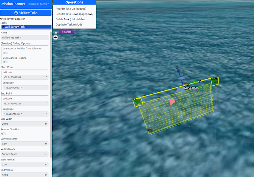
When a Wall Survey task is selected, the Hydrus follows a vertical lawn-mower pattern along a wall (or similar surface). It starts from the wall’s top or bottom survey corner, then moves horizontally back and forth until it gets to the opposite corner.
Wall Survey in front of Hydrus
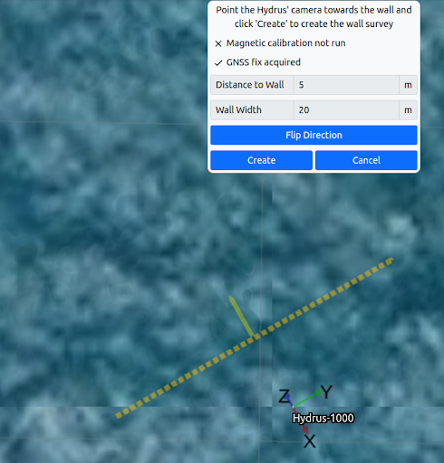
This task allows the user to accelerate wall survey mission planning by automatically generating a wall survey path at a position and orientation relative to the Hydrus’ current location and orientation.
To use this mode Hydrus should have a GNSS fix and valid magnetic heading out of the water, it should then be pointed with the camera end facing the wall to survey, or directly away from the wall to survey if this is not possible. The user can then enter a distance and width to survey.
Note: If pointing away from the wall, press the “Flip Direction” button to correct the direction. Once the data is correct, pressing the “Create” button will populate a “Wall Survey” task with the generated plan.
Once a survey task has been created, the user can manage the details for the survey.